The Beach at Cummington, Massachusetts
This is a guide for people interested in the
beach on the Westfield River in the town of Cummington,
Massachusetts. The illustrations accompanying this document are
all thumbnails and you can see a larger version by clicking on them.
Email the author if you
have comments on this document.
 The Cummington beach has had a long history of use by nudists. In the last few years, this
beach (which I'll just call "Cummington" from now on) has
attracted a lot of attention because of attempts by the Commonwealth
of Massachusetts to discourage people from using it. This has
occurred because of reports of sexual activity, mostly between male homosexuals, at
and near the beach. Many nudists now feel that Cummington has become
so much associated with open sex that it is effectively
unusable by anyone just seeking a pleasant day at the beach.
The Cummington beach has had a long history of use by nudists. In the last few years, this
beach (which I'll just call "Cummington" from now on) has
attracted a lot of attention because of attempts by the Commonwealth
of Massachusetts to discourage people from using it. This has
occurred because of reports of sexual activity, mostly between male homosexuals, at
and near the beach. Many nudists now feel that Cummington has become
so much associated with open sex that it is effectively
unusable by anyone just seeking a pleasant day at the beach.
The Naturist Action Committee of The Naturist Society is
aware of the situation at the Cummington nude beach but so far it has been
impossible to change either the users' behavior or the state's
policy.
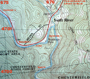
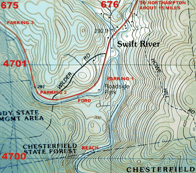
 Cummington is located in western Massachusetts, just south of Route
9, about 15 miles west of
Northampton. The beach itself is within the borders of
Chesterfield State Forest, and there is a large parking area nearby
on Route 9. The local map is taken from the USGS
"Goshen, MA" section and has been annotated to show the parking areas
and the beach itself. Numbers at left and top indicate the UTM
coordinates from the map edges, for use by GPS owners. The grid
lines are 1 kilometer apart (about 5/8 mile) and the contour interval
is 6 meters (20 feet). If you drive there, a useful landmark
is the marker for the town line between Goshen and Cummington. Once
this is passed, the parking lot is just over a mile farther. The
parking lot is a large roadside rest area on the south side
of Route 9, at a point where the road is going downhill and bending
to the right.
Cummington is located in western Massachusetts, just south of Route
9, about 15 miles west of
Northampton. The beach itself is within the borders of
Chesterfield State Forest, and there is a large parking area nearby
on Route 9. The local map is taken from the USGS
"Goshen, MA" section and has been annotated to show the parking areas
and the beach itself. Numbers at left and top indicate the UTM
coordinates from the map edges, for use by GPS owners. The grid
lines are 1 kilometer apart (about 5/8 mile) and the contour interval
is 6 meters (20 feet). If you drive there, a useful landmark
is the marker for the town line between Goshen and Cummington. Once
this is passed, the parking lot is just over a mile farther. The
parking lot is a large roadside rest area on the south side
of Route 9, at a point where the road is going downhill and bending
to the right.
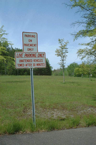
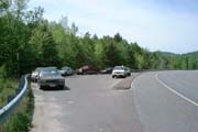
 What the state has done to reduce use (as of early June, 2000) has
been to install signs at the parking area stating "Unattended
cars towed after 30 minutes". The signs went up in 1999 and
there have definitely been reports of cars actually being towed.
What the state has done to reduce use (as of early June, 2000) has
been to install signs at the parking area stating "Unattended
cars towed after 30 minutes". The signs went up in 1999 and
there have definitely been reports of cars actually being towed.
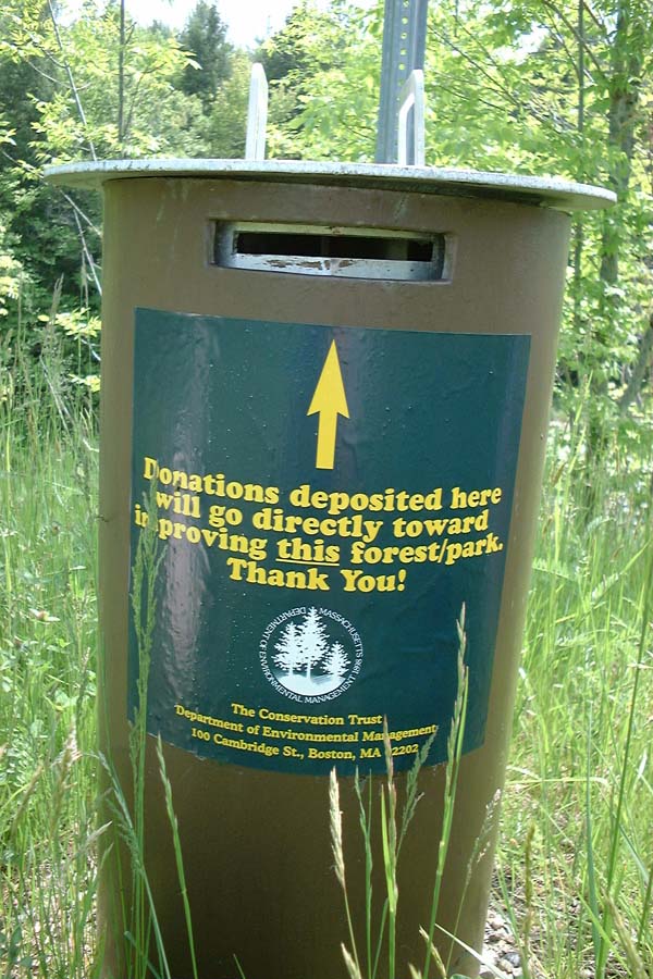
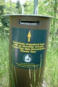
Visitors wishing to pay for
improvements (more "no parking" signs?) can do so via a donation box.
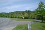
 Since the signs were placed, most people have parked at other, much
smaller, lots located about 0.5 miles and 1.3 miles west of the main
lot on Route 9. (The closer one is illustrated.) There is a poor-quality
path on the far side of the river, parallel to Route 9, which makes it
possible to reach at least the closer parking lot without using the
shoulder of the main road, but it is rough walking and involves fording
the river at a poorer location.
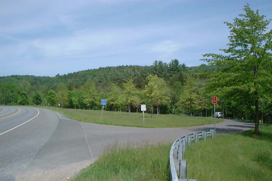
Since the signs were placed, most people have parked at other, much
smaller, lots located about 0.5 miles and 1.3 miles west of the main
lot on Route 9. (The closer one is illustrated.) There is a poor-quality
path on the far side of the river, parallel to Route 9, which makes it
possible to reach at least the closer parking lot without using the
shoulder of the main road, but it is rough walking and involves fording
the river at a poorer location.
Cummington's
remoteness means that there is effectively no way to reach it except
via Route 9, and for most people this means that private auto is the
only access. Some visitors do park elsewhere and ride bicycles to the
site, which is fairly easy because Route 9 has wide paved shoulders,
and traffic isn't usually very heavy. But leaving a bicycle out of sight
at the main parking area would be difficult.
 Once you reach the main parking area, follow the path leading past
the highway guard rail at the west end of the lot. This will take you
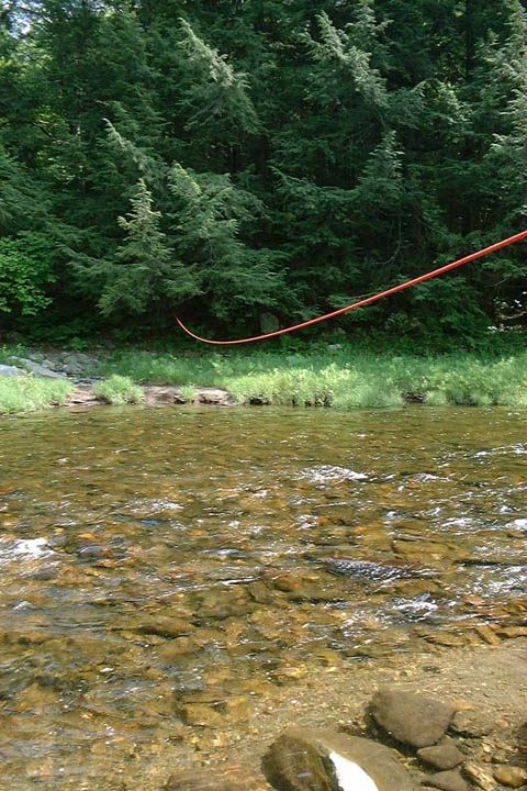
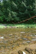
down to the water's edge, where it is necessary to ford the river.
The river crossing is difficult, and suitable footwear is necessary.
The water isn't deep, but it flows quickly and the bottom is made up of
small stones which are unstable and slippery with algae. As of June
2000, a rope was stretched across the river to hold onto, but this
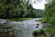
wasn't permanent. Once across the river, follow the path
through the woods. The trail branches in several places, but the
branches tend to re-join: the general direction is south, cutting
across a large bend of the river. The path crosses a small hill and
after about 1/2 mile, reaches the river again at the beach.
Once you reach the main parking area, follow the path leading past
the highway guard rail at the west end of the lot. This will take you
down to the water's edge, where it is necessary to ford the river.
The river crossing is difficult, and suitable footwear is necessary.
The water isn't deep, but it flows quickly and the bottom is made up of
small stones which are unstable and slippery with algae. As of June
2000, a rope was stretched across the river to hold onto, but this
wasn't permanent. Once across the river, follow the path
through the woods. The trail branches in several places, but the
branches tend to re-join: the general direction is south, cutting
across a large bend of the river. The path crosses a small hill and
after about 1/2 mile, reaches the river again at the beach.
In early summer you may wish to bring insect repellent.
Once you leave sight of the road, you're likely to encounter naked
people.
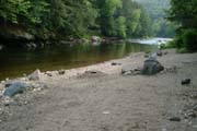
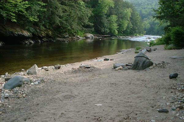
 When you get to the beach, what you'll find is a small sloping area
of sand and small stones, no more than 20 feet deep by 50 feet wide.
Fortunately, many of the gay beachgoers prefer to spread out on rocks
farther downstream, so the "main" beach is usually large enough for
everyone who wants to use it. I've heard of another beach area
downstream but although I've walked some way down the trail, I didn't
go far enough to see it. Apparently another stream crossing is needed.
When you get to the beach, what you'll find is a small sloping area
of sand and small stones, no more than 20 feet deep by 50 feet wide.
Fortunately, many of the gay beachgoers prefer to spread out on rocks
farther downstream, so the "main" beach is usually large enough for
everyone who wants to use it. I've heard of another beach area
downstream but although I've walked some way down the trail, I didn't
go far enough to see it. Apparently another stream crossing is needed.
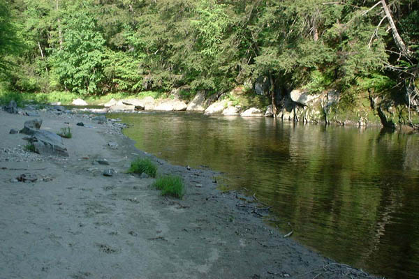
Wishing to be a polite nudist and avoid taking pictures of people, I
waited until late in the day, when the beach was deserted, before
getting the camera out. By this time, the sun had moved behind the
trees and hills. During the middle part of the day, there is good
sunlight and in fact it can be uncomfortably hot. The top of the beach
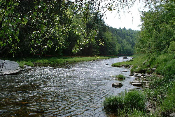
gets some shade. Upstream (right-hand picture), the river passes among
some boulders where one can sit and play with the flowing water.
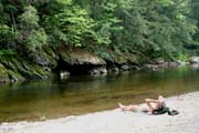
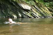 The river is about 20 feet wide at Cummington, shallow near the beach
but with a deep pool on the far side. The current is just about the
speed of a swimmer, so although the pool is small, you can swim
upstream indefinitely.
The river is about 20 feet wide at Cummington, shallow near the beach
but with a deep pool on the far side. The current is just about the
speed of a swimmer, so although the pool is small, you can swim
upstream indefinitely.
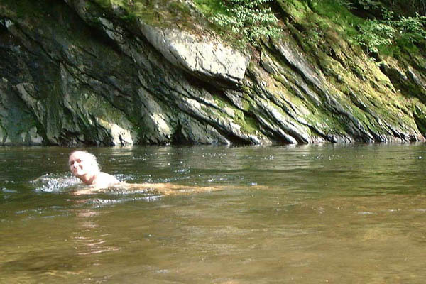
By midsummer the water has become warm enough
for comfortable swimming. When this picture was taken in early June,
the water was too cold to be pleasant, but a full report seemed to
demand a picture of someone in it!
The pictures were made with a FujiFilm MX-2700 digital camera and
subsequent processing was done with Adobe Photoshop.
BACK to my home page
 The Cummington beach has had a long history of use by nudists. In the last few years, this
beach (which I'll just call "Cummington" from now on) has
attracted a lot of attention because of attempts by the Commonwealth
of Massachusetts to discourage people from using it. This has
occurred because of reports of sexual activity, mostly between male homosexuals, at
and near the beach. Many nudists now feel that Cummington has become
so much associated with open sex that it is effectively
unusable by anyone just seeking a pleasant day at the beach.
The Cummington beach has had a long history of use by nudists. In the last few years, this
beach (which I'll just call "Cummington" from now on) has
attracted a lot of attention because of attempts by the Commonwealth
of Massachusetts to discourage people from using it. This has
occurred because of reports of sexual activity, mostly between male homosexuals, at
and near the beach. Many nudists now feel that Cummington has become
so much associated with open sex that it is effectively
unusable by anyone just seeking a pleasant day at the beach.